
Death Valley National Park, known in French as la vallée de la mort, is a desert rift valley in the Mojave, California, and the hottest, driest place in North America. The single most important rule: do not visit in summer. The official air temperature record stands at 56.7°C (134°F) at Furnace Creek, recorded on 10 July 1913, and modern summer days can reach very high temperatures. Plan your trip between November and April, carry at least four liters of water per person per day, and check road status with the National Park Service before you leave your hotel.
Before you read further, here is what every visitor needs to confirm:
- Season: November through April for safe, comfortable conditions.
- Gateway: Las Vegas (LAS) is approximately 2–2.5 hours by road; Los Angeles (LAX) is approximately 4–5 hours.
- First stop: Furnace Creek Visitor Center for road updates, maps and ranger advice.
- Water: Carry more than you think you need. Refill at Furnace Creek and Stovepipe Wells.
- Cell signal: Largely absent across the park. Download offline maps before you arrive.
What makes Death Valley so extreme?
Death Valley National Park spans over 3 million acres, making it the largest national park in the contiguous United States. Its elevation range is extraordinary: Badwater Basin sits approximately 86 meters (282 feet) below sea level, the lowest point in North America, while Telescope Peak rises to roughly 3,368 meters above it. That vertical spread of nearly 3,500 meters within a single park boundary is unusual anywhere on Earth.
| Fact | Detail |
|---|---|
| Total area | Over 3 million acres |
| Lowest point | Badwater Basin, ~86 m below sea level |
| Highest point | Telescope Peak, ~3,368 m above sea level |
| Average annual precipitation | ~5 cm (2 inches) |
| Official air temperature record | 56.7°C (134°F), Furnace Creek, July 10, 1913 |
| Park entrance fee (vehicle) | $35 USD per vehicle (7-day pass) |
| Annual pass | America the Beautiful Pass, $80 USD |
| Furnace Creek Visitor Center hours | Daily, typically 08:00–17:00 (verify with NPS before travel) |
Record temperature: The World Meteorological Organization recognized 56.7°C (134°F) at Furnace Creek on 10 July 1913 as the highest reliably recorded air temperature on Earth.
Entrance fees are paid in US dollars at park entrance stations or in advance via the NPS website. The America the Beautiful annual pass covers entry to all US national parks and is worth purchasing if you plan to visit more than two or three parks on the same trip. Always verify current fees and visitor center hours directly with the National Park Service before travel, as hours vary seasonally.
The main sights and how to group them
The park divides naturally into several geographic clusters. Grouping your visits by area saves significant driving time and allows you to catch the right light at each location.
Badwater Basin and Furnace Creek corridor
Badwater Basin is the park's most visited site and rightly so. The vast salt flat stretches to the horizon, its white crystalline surface broken into geometric polygons. It is accessible by a short, flat walk from the car park and is best visited at sunrise or after 4:00 p.m. to avoid the worst heat and the flattest midday light. Furnace Creek itself sits about 25 km north and serves as the park's main service hub, with the visitor center, petroleum, accommodation and a small shop.
Zabriskie Point, 15 minutes east of Furnace Creek by road, is the park's most photographed viewpoint. A short paved walk of roughly 400 meters from the car park reaches the overlook above eroded badlands in shades of gold and ochre. Arrive before sunrise or at least 30 minutes before sunset; the car park fills quickly and the light at those moments is exceptional.
Artist's Drive and Artist's Palette
Artist's Drive is a 14-km one-way loop off the main highway, accessible only to vehicles under 7.6 meters in length. The road winds through colored volcanic hills, culminating at Artist's Palette, where oxidised minerals paint the hillside in green, pink, purple and orange. Late afternoon light intensifies the colors considerably. Allow 45–60 minutes for the full loop.
Mesquite Flat Sand Dunes
The Mesquite Flat dunes rise near Stovepipe Wells and are the most accessible dune field in the park. The walk to the main crest takes roughly 30–45 minutes each way across soft sand. Go at dawn for cool air, long shadows and the chance to photograph undisturbed ripple patterns before other visitors arrive. By mid-morning in spring the dunes are busy; in summer they are genuinely dangerous before 08:00.
Dante's View
At 1,669 meters, Dante's View offers a panoramic view across the entire valley floor, with Badwater Basin visible nearly 1,800 meters below. The drive from Furnace Creek takes about 35 minutes. Sunrise here is spectacular, though the road is steep and narrow; arrive early to secure parking.
Racetrack Playa and the northern loop
Racetrack Playa is famous for its “sailing stones”, rocks that leave tracks across the dry lake bed, a phenomenon now explained by thin ice sheets and wind. The access road from Ubehebe Crater is approximately 43 km of rough dirt track and requires a high-clearance or four-wheel-drive vehicle. Check NPS road-status pages before attempting this route; washouts can close it without warning. Ubehebe Crater itself, a volcanic maar roughly 240 meters wide and 150 meters deep, is worth a stop on the way.
Always check the NPS road-status page before setting out, particularly for the northern loop and any unpaved tracks.
Sample itineraries: one day to four days
Day trip from Las Vegas
A day trip is feasible but demanding. Depart Las Vegas by 06:00 to reach Furnace Creek by approximately 08:30. Spend the morning at Zabriskie Point, Badwater Basin and the Artist's Drive loop, then return via Stovepipe Wells for a brief stop at Mesquite Flat. Leave the park by 3:00 p.m. to avoid driving the desert highway in peak afternoon heat and to be back in Las Vegas by early evening.
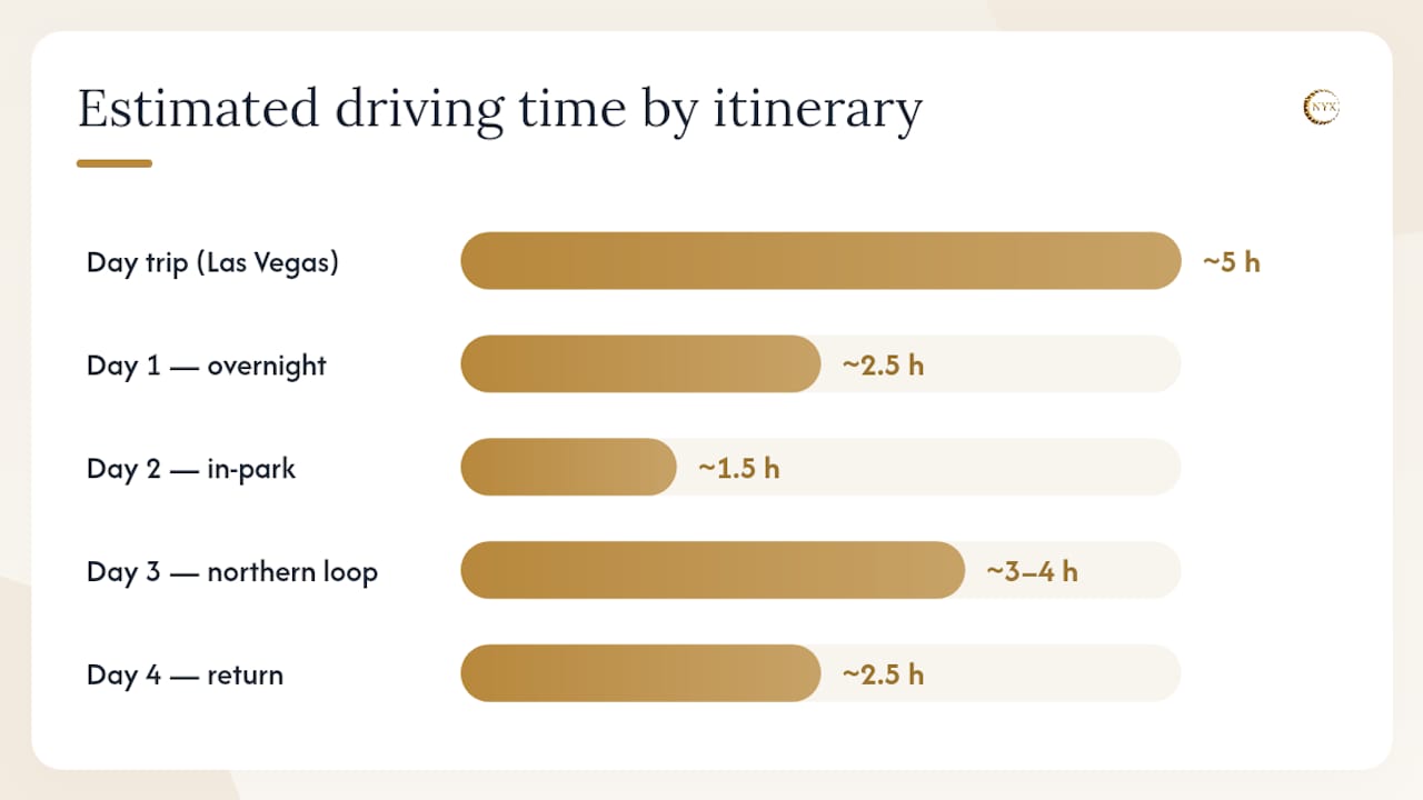
| Day | Key stops | Estimated driving time |
|---|---|---|
| Day trip (Las Vegas base) | Zabriskie Point, Badwater Basin, Artist's Drive, Mesquite Flat | ~5 hours total driving |
| Day 1 (overnight stay) | Furnace Creek, Zabriskie Point at sunset, Badwater Basin at dawn | ~2.5 hours from Las Vegas |
| Day 2 | Artist's Drive, Mesquite Flat dunes, Dante's View | ~1.5 hours in-park driving |
| Day 3 | Northern loop: Ubehebe Crater, Racetrack Playa (4×4 required) | ~3–4 hours for the loop |
| Day 4 | Telescope Peak hike or Salt Creek, return to gateway city | ~2.5 hours to Las Vegas |
Two-day plan
Arrive in the late afternoon of Day 1 and head straight to Zabriskie Point for sunset. Stay overnight at Furnace Creek or Stovepipe Wells. On Day 2, begin at Badwater Basin at dawn, then work through Artist's Drive, Mesquite Flat dunes and Dante's View before leaving. This plan covers the park's most iconic scenery without requiring a 4×4.
Three to four days
A three or four-day visit allows the northern loop, a serious hike (Golden Canyon, Mosaic Canyon or Telescope Peak), and time to absorb the park's quieter corners. Build in a contingency day for road closures, which are common after rain. The drive from Los Angeles to Furnace Creek via CA-190 takes approximately 4–5 hours; factor this into your first and last days.
When should you visit Death Valley?
The National Park Service recommends late autumn through spring as the optimal window for visiting Death Valley. October through April offers manageable daytime temperatures and the best conditions for hiking and photography.
Winter nights at higher elevations, particularly around Telescope Peak, can drop well below freezing. Pack layers even if you plan to spend most of your time on the valley floor.
The 1913 record in context: The WMO-recognized record of 56.7°C was measured at Furnace Creek on 10 July 1913. Modern monitoring methods and station standards have evolved since then, and the WMO's assessment process involved careful review of the original data. The record stands, but it reflects conditions at the valley floor in peak summer, not typical visitor conditions in the recommended season.
Spring is the most popular season and the only time a superb bloom is possible. Autumn is quieter and still warm enough to enjoy the salt flats and viewpoints comfortably. For photographers, the low winter sun angle produces long shadows and rich color across the badlands from November through February.
How to reach Death Valley from the UK and major gateways
Flying from the UK
Most UK travelers fly into Las Vegas Harry Reid International (LAS) or Los Angeles International (LAX). Direct seasonal services from London Heathrow and Gatwick to Las Vegas take approximately 10–11 hours; Flights to Los Angeles run roughly 11 hours. From Las Vegas, Furnace Creek is approximately 220 km by road, typically 2–2.5 hours via US-95 South and CA-190 West. From Los Angeles, the drive via CA-14 North and CA-190 East is approximately 380–400 km, taking 4–5 hours depending on traffic leaving the city.

| Gateway | Distance to Furnace Creek | Typical drive time | Main road |
|---|---|---|---|
| Las Vegas (LAS) | ~220 km | 2–2.5 hours | US-95 S, CA-190 W |
| Los Angeles (LAX) | ~380–400 km | 4–5 hours | CA-14 N, CA-190 E |
| Beatty, Nevada | ~120 km | ~1.5 hours | US-95 S |
Vehicle preparation
Self-driving is the only practical way to explore the park fully. Before departure from your gateway city, carry out these checks:
- Coolant and radiator: Verify fluid levels; overheating is a common cause of breakdowns on the valley floor.
- Tyres: Check pressure and carry a spare; sharp rocks on unpaved roads cause punctures.
- Fuel: Fill up before entering the park. Petrol is available at Furnace Creek and Stovepipe Wells but at a significant premium.
- Water: Carry a minimum of four liters per person beyond what you plan to drink on hikes.
- Emergency kit: A basic vehicle maintenance checklist is a useful reference for long desert drives.
For travelers who prefer not to self-drive the long desert legs, professional private transfer services can cover the Las Vegas or Los Angeles to Death Valley gateway stretch. Transponyx (+33 6 10 30 71 84, Transponyx) specializes in long-distance private transfers with fixed 2026 rates and professional bilingual drivers, and can advise on routing for multi-destination US itineraries that include a French Riviera leg.
Park entry, visitor centers and rules you must follow
Entry fees and passes
The standard vehicle entry fee is $35 USD for a 7-day pass, covering all occupants of a private vehicle. Motorcycles pay $30 USD; pedestrians and cyclists pay $20 USD per person. The America the Beautiful annual pass ($80 USD) covers entry to all US national parks and is the best value for travelers visiting multiple parks. Passes can be purchased at entrance stations or in advance via the NPS website.
Furnace Creek Visitor Center
The Furnace Creek Visitor Center is the park's primary information hub, open daily (hours vary seasonally; confirm with NPS before travel). Rangers provide current road conditions, weather forecasts and trail advice. Ranger-led programs run daily during the winter season and some specialized tours require advance reservation. Collecting a printed park map here is strongly advised given the limited cell coverage throughout the park.
Rules every visitor must observe
- Do not drive or walk on the salt flats beyond designated areas; the crust is fragile and damage is permanent.
- Leave all geological and biological features in place; removing rocks, plants or wildlife is illegal.
- Camp only in designated campgrounds or pre-approved backcountry zones.
- Pack out all waste; no rubbish bins are available in remote areas.
- Keep to marked trails to protect both the landscape and yourself.
Which hikes track your fitness level?
Short walks (under 2 hours)
Mesquite Flat dunes: The walk to the main crest is roughly 2.5 km return across soft sand, taking 45–60 minutes. No trail markers; navigate by sight. Best before 09:00 or after 17:00 in spring.
Zabriskie Point loop: A 400-meter paved path from the car park to the viewpoint, suitable for all fitness levels. Allow 20–30 minutes.
Badwater salt flat walk: A flat, well-marked path extends roughly 1.6 km onto the salt flat. The surface is firm near the car park and becomes rougher further out. Allow 30–45 minutes return.
Moderate hikes (2–4 hours)
Golden Canyon: A 5-km return trail through eroded canyon walls of red and gold. The trailhead is 5 km south of Furnace Creek on Badwater Road. Moderate gradient; allow 2–3 hours.
Mosaic Canyon: A 6.4-km return hike through polished marble narrows near Stovepipe Wells. The canyon walls are smooth and striking. Allow 2–3 hours; the upper section involves some scrambling.
Strenuous hike: Telescope Peak
The summit trail is approximately 22 km return with an elevation gain of roughly 1,600 meters. Allow a full day; start no later than 07:00. In winter, snow and ice require microspikes or crampons. The trailhead is at Mahogany Flat campground, accessible by a rough dirt road.
Safety on every hike
Carry at least one liter of water per hour of hiking. Wear a broad-brimmed hat, high-SPF sun cream and light-colored, breathable clothing. Avoid hiking between 11:00 and 16:00 from March onwards. Tell someone your planned route and expected return time, and check in with a ranger if you are attempting a remote or strenuous trail.
Where to stay inside and near the park
In-park lodging
Tea Inn at Death Valley (Furnace Creek area) is the park's premium property, with a spring-fed pool and full-service dining. Tea Ranch at Death Valley, adjacent to the Inn, offers more accessible room rates with motel-style accommodation and a larger pool. Both properties book out months in advance for the October through April season; reserve early.
Stovepipe Wells Village provides motel rooms, a restaurant and a petroleum station roughly 40 km north-west of Furnace Creek. Panamint Springs Resort, near the park's western boundary, is a quieter option with basic cabins and a small bar.
Camping
The park has several developed campsites. Furnace Creek Campground is the largest and most central, with reservations available via Recreation for the peak season. Mesquite Spring, Wildrose and Thorndike campgrounds are free and first-come, first-served. Backcountry camping is permitted at least 1.6 km from roads and water sources, with no open fires.
Nearby towns
Beatty, Nevada (~120 km from Furnace Creek) and Pahrump, Nevada (~130 km) offer budget motel options and full fuel and grocery services. Lone Pine, California (~130 km south-west), is a useful base for combining Death Valley with a visit to Mount Whitney or the Eastern Sierra.
Practical note: Fuel inside the park is expensive and occasionally unavailable. Fill your tank in Beatty, Pahrump or Lone Pine before entering, and again whenever you pass a station inside the park.
Photography in Death Valley: timing and technique
The park rewards photographers who move early and stay late. The hour after sunrise and the hour before sunset produce the warmest, most directional light across the badlands, dunes and salt flats.
Zabriskie Point is the park's most competitive sunrise spot; arrives 45 minutes before first light to secure a position on the overlook. The eroded ridges glow amber and gold as the sun clears the Amargosa Range. For a less crowded composition, walk 200–300 meters along the ridge path away from the main platform.
The Mesquite Flat dunes are best at dawn, when the sand surface is unmarked and the low light casts long shadows across the ripple patterns. Shoot from a low angle to emphasize texture and depth. A polarizing filter reduces glare on the salt flats at Badwater; after rare rainfall, a thin film of water on the flat creates mirror-like reflections worth the extra effort.
Artist's Palette is most vivid in the 90 minutes before sunset, when the warm light intensifies the mineral colors. The one-way road means you cannot linger indefinitely; plan your timing before entering the loop.
Expert insight: Early mornings produce cool, blue-toned light that renders the salt flats and volcanic rock in subtle, graphic tones. Late afternoons deliver warm amber and orange that saturate the badlands and dunes. The two moods are entirely different; experienced photographers often visit the same location twice in a single day to capture both.
Death Valley is also a designated International Dark Sky Park. During new-moon windows, the Milky Way is visible with the naked eye from most of the valley floor. Move away from Furnace Creek's ambient lighting for the clearest skies; the Mesquite Flat area and the road towards Racetrack Playa are particularly dark.
Flora, fauna and the superbloom
Death Valley is the driest region in North America, with average annual precipitation of approximately 5 centimeters. That figure makes the park's ecological diversity all the more striking.
Record rainfall: Average annual rainfall of ~5 cm (2 inches) makes Death Valley the driest place in North America, yet it supports hundreds of plant species and several endemic animal populations.
Salt Creek harbors the Salt Creek pupfish, a small endemic species that has adapted to water several times saltier than the ocean. The boardwalk trail at Salt Creek (best visited in February and March when pupfish are most active) offers a close view without disturbing the habitat. Stay on the boardwalk; the surrounding soil crust is fragile.
Desert plants including creosote bush, desert holly and various cacti are present across the valley floor. At higher elevations, pinyon pine and juniper appear. After unusually heavy winter rainfall, the valley floor can produce a superbloom: a dense carpet of wildflowers, predominantly desert gold and phacelia, that covers the lower slopes and flats. Superblooms are rare, weather-dependent and typically occur in March or early April. They cannot be predicted reliably more than a few weeks in advance; follow NPS social media and the VisitCalifornia wildflower tracker in late winter if this is a priority.
Responsible viewing matters. Stay on marked paths, do not pick flowers, and avoid walking across the salt crust or sandy soil between plants, which compacts the ground and damages root systems.
Why is it called Death Valley?
The name dates to the winter of 1849–1850, when a group of gold rush emigrants crossed the valley while searching for a shortcut to the California goldfields. Several members of the party died from heat and dehydration. As the survivors finally climbed out of the valley, one woman is reported to have looked back and said, “Goodbye, Death Valley.” The name persisted.
The valley was not, however, uninhabited before the 49ers arrived. The Timbisha Shoshone people have lived in and around the valley for centuries, and their presence predates European contact by thousands of years. The Timbisha Shoshone Tribe maintains a village near Furnace Creek today. Visitor centers provide context on both the indigenous history and the later mining era, which brought borax extraction operations to the valley in the 1880s. The Twenty Mule Team wagons used to haul borax across the desert became one of the American West's enduring images.
For deeper historical reading, the NPS visitor center at Furnace Creek stocks interpretive materials and can direct visitors to cultural sites within the park.
Navigation, cell coverage and offline maps
Cell coverage is extremely limited across most of the park. The Furnace Creek area has partial signal on some networks, but large sections of the valley floor, all unpaved roads and the entire northern loop have no reliable coverage at all. Do not rely on a smartphone for navigation once you leave the main highway.
Before you arrive:
- Download the NPS Death Valley offline map from the official NPS app or from a dedicated mapping application such as Gaia GPS or Maps.me with topo tiles covering the full park area.
- Carry a printed park map, available free at the Furnace Creek Visitor Center or downloadable from the NPS website.
- A standalone GPS unit with pre-loaded topographic maps is advisable for any unpaved route.
Fuel planning is equally critical. Petrol is available at Furnace Creek and Stovepipe Wells inside the park, and at Beatty and Pahrump outside. The distance between services on some routes exceeds 100 km; calculate your range conservatively and never let the tank drop below a quarter full.
Some remote routes, including the Racetrack Playa access road, require high-clearance or four-wheel-drive vehicles. Check the NPS road-status page at nps.gov/deva immediately before departure; Conditions change rapidly after rain.
Planning your trip from the UK
Flight routing
The most direct routing from the UK to Death Valley is London Heathrow or Gatwick to Las Vegas Harry Reid International (LAS), with seasonal direct services taking approximately 10–11 hours. From Las Vegas, the drive to Furnace Creek is roughly 2–2.5 hours. Alternatively, fly London to Los Angeles (LAX) in approximately 11 hours, then drive 4–5 hours via CA-14 North and CA-190 East. Los Angeles gives more flexibility for combining Death Valley with other California destinations.
Visa and entry requirements
Most UK passport holders qualify for the US Visa Waiver Program and must apply for an ESTA (Electronic System for Travel Authorization) before departure. Applications are made online via the official US Customs and Border Protection website; approval is typically granted within minutes but should be obtained at least 72 hours before travel. Travelers who do not qualify for the visa waiver must apply for a B-2 tourist visa through the US Embassy in London. Verify current requirements directly with the UK Government travel guidance before booking.
Practical tips for UK travelers
- Currency: US dollars are the only accepted currency inside the park. Major credit cards are accepted at Furnace Creek and Stovepipe Wells, but carry cash for smaller purchases and campground fees.
- Time zones: Death Valley operates on Pacific Time (UTC-8 in winter, UTC-7 in summer). The UK is 8–9 hours ahead, depending on daylight saving.
- Luggage: Pack light, breathable clothing, a wide-brimmed hat, high-SPF sun cream, a reusable water bottle of at least 1.5 liters, and a warm layer for evenings and higher elevations.
- Ground transfers: For the long-distance leg from your UK departure airport to a French Riviera connection, or for any pre-trip or post-trip transfer on the Côte d'Azur, Transponyx provides fixed-rate private transfers with bilingual professional drivers. Contact via +33 6 10 30 71 84 or Transponyx.
Accessibility at Death Valley
Several of the park's most celebrated viewpoints are accessible to visitors with limited mobility, though the terrain varies considerably across the park.
- Zabriskie Point: The paved path from the car park to the main overlook is short and manageable for most wheelchair users, though the surface has a slight incline.
- Badwater Basin: The car park is large and the initial section of the salt flat walk is firm and relatively flat, making it accessible for wheelchairs and mobility aids for the first several hundred meters.
- Furnace Creek Visitor Center: Fully accessible, with accessible parking, ramps and restrooms.
- Mesquite Flat dunes: The car park is accessible, but the dune surface itself is soft sand and unsuitable for wheelchairs or mobility aids.
- Artist's Palette (Artist's Drive): The road is paved and the viewpoint can be enjoyed from the vehicle window; there is no formal accessible path at the palette itself.
- Racetrack Playa and northern unpaved routes: Not suitable for standard wheelchairs or low-clearance vehicles.
Contact the Furnace Creek Visitor Center directly before your visit to ask about current accessible trail conditions and any available assistance. The NPS accessibility page for Death Valley provides updated information on facilities and programs.
Emergency services and communications in Death Valley
The remoteness of Death Valley makes emergency preparedness non-negotiable. Cell coverage is absent across most of the park, and the nearest full-service hospital is a significant drive from the valley floor.
Nearest hospitals
The closest hospital with emergency services is Desert View Hospital in Pahrump, Nevada, approximately 100 km from Furnace Creek. For serious trauma, patients are typically transferred to University Medical Center in Las Vegas, roughly 220 km away. Response times from remote areas of the park can exceed two hours.
Ranger stations and emergency contacts
- Furnace Creek Visitor Center/Ranger Station: The primary contact point inside the park. Rangers can coordinate search and rescue operations and provide first aid.
- Emergency number: Dial 911 where cell signal exists. In areas without coverage, use a satellite communicator (such as a Garmin inReach or SPOT device) to send an emergency SOS signal.
- NPS dispatch: Rangers monitor radio frequencies and conduct regular patrols, but response to remote locations takes time.
Emergency procedures
If your vehicle breaks down or you become lost, stay with your vehicle. It is far easier for rescuers to locate a stationary vehicle than a person on foot in open desert. Display a distress signal (a brightly colored cloth or your vehicle's hazard lights) and conserve water. If you have a satellite communicator, activate it immediately.
Before any remote excursion, file a trip plan with a ranger or leave written details of your route and expected return time with someone outside the park. Carry a minimum of four liters of water per person per day, a first-aid kit, a whistle, a torch and an emergency foil blanket. Heat stroke can develop within minutes in summer conditions; know the symptoms (confusion, cessation of sweating, rapid pulse) and treat it as a life-threatening emergency.
A travel journalist's perspective on visiting Death Valley
The question I am most often asked about Death Valley is how long to spend there. My honest answer is that two nights is the minimum for anyone who wants to do more than tick off the famous viewpoints. The first evening at Zabriskie Point and the first dawn at Badwater Basin will change how you see the place entirely. You need that second morning to absorb it rather than simply photograph it.
The overnight argument is not just about light, though the light is extraordinary. Death Valley is a designated International Dark Sky Park, and a clear night away from Furnace Creek's ambient glow is one of the most genuinely affecting experiences the American West offers. Travelers who drive in and out in a single day miss this completely.
For photographers, three nights is the best investment. The northern loop to Racetrack Playa deserves its own day, and the drive itself, through volcanic terrain with almost no other traffic, is part of the experience. For hikers, add a fourth day for Telescope Peak, which rewards the effort with views across two states on a clear winter morning.
The practical transport question matters more than most guides acknowledge. The Las Vegas to Furnace Creek drive is straightforward, but it is long and the return leg after a full day in the park is tiring. For groups or travelers combining Death Valley with a broader US itinerary that includes a French Riviera connection, arranging a professional private transfer for the gateway legs removes one significant variable from an already demanding trip. Transponyx (Transponyx) handles exactly these kinds of long-distance, fixed-rate transfers with the reliability that complex itineraries require.

Sources
The following official sources should be your first reference for road conditions, weather, bookings and safety updates. Consult them in the days immediately before travel, not just at the planning stage.
FAQ
Why is it called Death Valley?
The name comes from the winter of 1849–1850, when a group of gold rush emigrants crossed the valley and several members died from heat and dehydration. As survivors left, one is said to have called out “Goodbye, Death Valley,” and the name endured.
What is the record temperature in Death Valley?
The official record is 56.7°C (134°F), recorded at Furnace Creek on 10 July 1913, recognized by the World Meteorological Organization as the highest reliably measured air temperature on Earth.
Why is Death Valley so famous?
Death Valley holds multiple world extremes: the hottest recorded air temperature on Earth, the lowest point in North America at Badwater Basin (~86 m below sea level), and the driest conditions in North America, with average annual rainfall of just 5 centimeters. Its combination of dramatic scenery and record-breaking geography makes it one of the most visited national parks in the United States.
How long does it take to visit Death Valley properly?
A day trip from Las Vegas covers the main viewpoints but leaves little time to absorb the park. Two nights allows sunrise and sunset at the key sites; three to four days is recommended for the northern loop, serious hiking and stargazing.



0 Comments